The area is San Siro and everything starts from this traffic light: what was here, what is here and what is planned.
Now · press review
Latest news
The press review lists only headline, outlet and date: the article is read on the site that publishes it. Headlines stay in Italian.
Where to start
Three ways into the area
For history seekers
A hundred years from the traffic lights
San Siro area · the new stadium
Generali Stadium
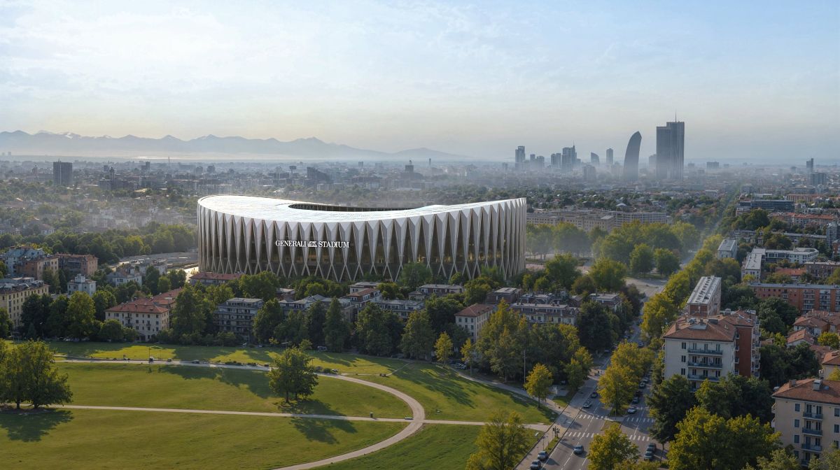
Milan and Inter’s new stadium will rise next to the Meazza, in the San Siro area, about 600 metres from the traffic lights of via Novara and via San Giusto. The design is by Foster + Partners and MANICA and was presented on 29 October 2026 at the Castello Sforzesco. The clubs give 2028 for the start of works and the 2031/32 season for the first match, if the permits arrive.
All about the Generali StadiumThe clubs’ statement and rendersThe presentation film, Inter TV
Every item rests on at least two sources, listed on the new stadium page. The renders belong to the clubs and can be seen on their pages.
Two stadiums, on the same ground
Today’s stadium
100
years, since 19 September 1926
On the first day, four stands in open country and a derby: Milan–Inter 3–6. Then the curved ends in 1935, the second tier in 1955, the third tier and the eleven towers for the 1990 World Cup. On 19 September 2026 the stadium turned one hundred.
Plan and volumes
Il quartiere disegnato, dal semaforo
Buildings in black, streets in white, green and sports grounds in the section colours: the plan is drawn from OpenStreetMap data, with building volumes where the height is recorded. The 3D button shows the volumes; drag to rotate.
Getting there
To the stadium and the crossroads, without a car
On match and concert days the streets around the stadium are closed, and after the event the San Siro Ippodromo and Segesta stops close too. Routes from Centrale, Cadorna and the ring road: getting here, line by line.
Water kiosks, recycling point, hospital, library and district office: services around the crossroads.
On foot from the crossroads
On this day
All anniversariesEvent archive
The community tells
Those who were there write with us
“The San Siro Sports Palace was so wonderful. Architecturally daring, perhaps even too much, but wonderful.” (translated from Italian)
Memories are published as their authors write them, with their consent. Dates and facts are checked against two sources: where they differ, the clarification goes underneath and the memory stays as it is.
Timeline
A hundred years of the stadium, in nine dates
- 19 September 1926Opens with Milan–Inter 3–6.
- 1935The City of Milan buys the stadium.
- 13 May 1939The stands close into a ring: Italy–England.
- 14 September 1947Inter make San Siro home: Inter–Modena 1–1.
- April 1956Official opening of the second tier: Italy–Brazil 3–0.
- 2 March 1980The stadium is named after Giuseppe Meazza.
- 25 April 1990Third tier and roof, for the World Cup.
- 5 November 2025Deed of sale: stadium and land pass to Milan and Inter.
- 19 September 2026A hundred years.
Then · the history of the area
Before the stadium, and around it
Six chapters to start with: the fields, the village, the Palasport, the law that built the housing, the street names, the flight at Baggio.
All the storiesPeriod photographs
The neighbourhood, before and after the housing
Architecture and painted walls
Landmark buildings and murals, starting from the crossroads
On the two streets of the crossroads stand two buildings by Piero Bottoni. Around them, works by Gio Ponti and Angelo Mangiarotti, and a series of murals painted with the schools and the neighbourhood.
- Three-cylinder house, via Gavirate 27, 2015Arbalete · Wikimedia Commons · CC BY-SA 4.0
- The same house in 1970Paolo Monti · BEIC / Wikimedia Commons · CC BY-SA 4.0
- The lobby, with the column supporting the cylinders, 1970Paolo Monti · BEIC / Wikimedia Commons · CC BY-SA 4.0
- Ponti’s colours, Harar estatePaolo Monti · BEIC / Wikimedia Commons · CC BY-SA 4.0
Architecture
- 1951The buildings by Bottoni, Morini and Villavia Novara 92 · via San Giusto 37
- 1956Three-cylinder housevia Gavirate 27 · Mangiarotti e Morassutti
- 1964The church of San Carlo hospitalGio Ponti, Antonio Fornaroli, Alberto Rosselli
- 2025CASVA, in the former QT8 marketvia Isernia 5
Murals
- 2019The racecourse wallStreet Players · from via Diomede to viale Caprilli · repainted in 2022
- 2024A Team of DevilsOrticanoodles · piazzale dello Sport 6
- 2020Vesod’s muralpiazzale Selinunte
- 2025Travelogue Muralvia Paravia angolo via Preneste
- 2018Talking WallsOrticanoodles · piazzale Zavattari
The green west of the crossroads
Four parks, from via Novara
What is here, and what is coming
Video
The area, in four videos
The stadium from above, the Horse at the racecourse, Boscoincittà and the plan for the new stadium. Each video loads only when clicked.
The stadium from above
Leonardo’s Horse
The green, to the west
The new stadium
The stadium, in a few minutes
The teams
Four teams, one neighbourhood
This site
An independent local archive
It is the archive of the San Siro community: people who live here, work here, go to the stadium or the parks. Memories, family photographs and tips come in through the Facebook page and are published with the consent of whoever sends them (Community, with a guide to the area for residents). An independent, non-profit project: no advertising, no sales, no ties to news outlets or public bodies. The public point of contact is the Facebook page «San Siro e dintorni», and that is where tips, corrections and removal requests come in.
The scope is the San Siro area, across Municipi 7 and 8: from the crossroads towards the stadium, QT8 and the old Fair, and towards Baggio and the green to the west. Every fact is checked against at least two independent sources and, where one exists, the official source; where sources disagree, the primary source prevails. The press review and calendar are updated every day. The ten rules, with examples, are in Method. The sources one by one in Sources, and the legal notes.
Sources for this page
- OpenStreetMap contributorsPlan and volume data (buildings, streets, green areas, heights), ODbL licenceopenstreetmap.org/copyright
The full directory of official sources, with the selection criteria, is in Method.
What this page rests on
Every fact is checked against at least two independent sources and, where one exists, the official source.
Two independent sources
Dates, measurements and names go through at least two sources that do not copy each other. Where it exists, we go to the original: the deed, the archive, the body that owns it. What appears in only one place waits.
One version only
If two sources disagree, the original document prevails. If even that is not enough, only the part they agree on is written: the year, for example, instead of the day.
Updated every day
The press review and calendar are updated every day. Everything else changes when a new document turns up, and then it changes everywhere at once.
From the community
Many memories, family photographs and tips come from people who live here, writing to the Facebook page. They are published only if the sender agrees. How to take part: Community.
Everything traceable
Sources are listed above and on the page Sources, with archive, shelfmark and terms of use.
No interpretation passed off as fact
An approximate figure stays approximate, a project stays a project until construction starts, and whatever does not add up stays out. The criteria are in Method.